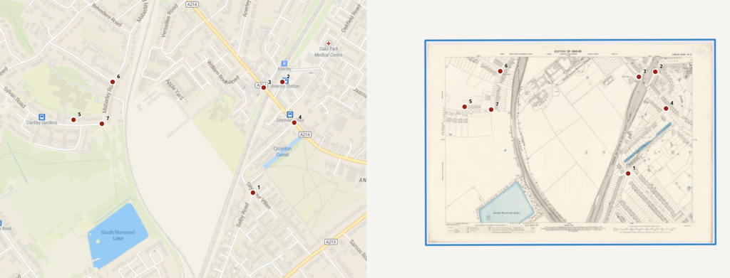
The process of georeferencing this map was interesting because it challenged my ability to recognize patterns between the maps and because seeing the changes to the location over time was cool. This particular map, depicting a specific area of London, was randomly generated, so it already had three points georeferenced by another user, but I was able to add four more– points 4, 5, 6, and 7– by comparing street corners, intersections and specific buildings.
There are many possibilities with georectified maps. As I mentioned earlier, the ability to compare how particular areas changed over time is particularly interesting. Although, due to the nature of the resources, it’s very possible any difference between the old map and the modern digital map is more caused by developments in cartographical accuracy over time than any physical change. However, when it comes to comparing buildings, for example, which would likely have changed since the map’s publication in 1896, it’s interesting to see developments over time. In terms of what georeferenced maps could allow in a project, next steps could be to georeference and compare an additional map of the area created at a different time than the original, to further examine how cartography of the area might have changed over time. Alternatively, georeferencing and comparing another map made at around the same time as the first map (1890s) of the same area might allow a comparison of the accuracy of each map.
However, one of the main problems with this system of georeferencing is that, on this website at least, the points are user-contributed and do not require citation, meaning bad actors contributing data may create incorrrect georectified maps. Because of this, relying on georeferencing for specific information might be unreliable. Knowing not only the context behind the georeferencing but also the context behind the original map creation is therefore very useful in understanding how to use a georectified map. By understanding the possible cartographical inaccuracies or biases in the historical map, someone studying it can better use it for research, instead of accepting the representation in the map as fully accurate.
This process somewhat changed my understanding of spatial DH projects. I now have a better understanding of how projects like these are created, which is helpful, but the process has not really changed my perception or opinion on the projects themselves.
